Browse Resources
Higher Education -- Technical Education (Upper Division)
Resources |
|---|
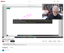
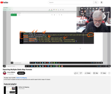
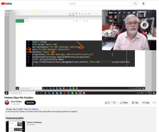
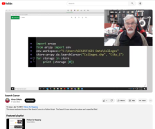
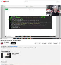
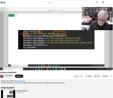 This video lesson, provided by the GeoTech Center, is from the eighth module of the Python and Geospatial Mapping course, titled More Python. The course is designed for experienced users of Global Information Systems (GIS) platforms who are new to programming, with the goal of teaching them how to...
 This video lesson, provided by the GeoTech Center, is from the eighth module of the Python and Geospatial Mapping course, titled More Python. The course is designed for experienced users of Global Information Systems (GIS) platforms who are new to programming, with the goal of teaching them how to...
 This video lesson, provided by the GeoTech Center, is from the eighth module of the Python and Geospatial Mapping course, titled More Python. The course is designed for experienced users of Global Information Systems (GIS) platforms who are new to programming, with the goal of teaching them how to...
 This video lesson, provided by the GeoTech Center, is from the eighth module of the Python and Geospatial Mapping course, titled More Python. The course is designed for experienced users of Global Information Systems (GIS) platforms who are new to programming, with the goal of teaching them how to...
 This video lesson, provided by the GeoTech Center, is from the eighth module of the Python and Geospatial Mapping course, titled More Python. The course is designed for experienced users of Global Information Systems (GIS) platforms who are new to programming, with the goal of teaching them how to...
 This video lesson, provided by the GeoTech Center, is from the eighth module of the Python and Geospatial Mapping course, titled More Python. The course is designed for experienced users of Global Information Systems (GIS) platforms who are new to programming, with the goal of teaching them how to...
 This video lesson, provided by the GeoTech Center, is from the eighth module of the Python and Geospatial Mapping course, titled More Python. The course is designed for experienced users of Global Information Systems (GIS) platforms who are new to programming, with the goal of teaching them how to...
 This video lesson, provided by the GeoTech Center, is from the eighth module of the Python and Geospatial Mapping course, titled More Python. The course is designed for experienced users of Global Information Systems (GIS) platforms who are new to programming, with the goal of teaching them how to...
 This video lesson, provided by the GeoTech Center, is from the eighth module of the Python and Geospatial Mapping course, titled More Python. The course is designed for experienced users of Global Information Systems (GIS) platforms who are new to programming, with the goal of teaching them how to...
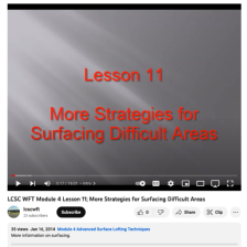 This video is part of a series of mold making training modules by Lewis-Clark State College. This series of modules covers how to make simple molds using SolidWorks CAD software and how to modify the molds to improve performance. This video shows an alternative method on how to address surfacing...
|
| ← PreviousNext → |